The Pacific Northwest Faces Extreme Rain and Snow as Powerful December Storms Line Up
Posted on 12/05/25 at 14:57
- Intense storms to hit the Pacific Northwest
- Elevated flood and landslide risks
- Heavy mountain snow impacting travel
According to AccuWeather, the Pacific Northwest is facing a severe winter pattern with heavy rain, snow, and growing risks of flooding, landslides, and avalanches as multiple storms line up throughout December.
AccuWeather meteorologists warn that the region will experience dangerous conditions as atmospheric systems strengthen and deliver significant moisture, especially to higher elevations.
The first storm will only preview what is expected to be a prolonged and impactful stretch of winter weather, highlighting the potential severity of the climate pattern through much of December.
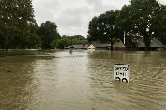
This setup increases regional vulnerability, particularly in areas prone to soil saturation, unstable snowpack, and rapid flooding triggered by heavy, persistent rainfall.
Early storms reveal the winter pattern
Pacific Northwest bracing for flooding rain, yards of snow as December storms line up https://t.co/RRkZqjpkhp via @YahooNews
— Thomas Appleby (@ThomasAppl21720) December 4, 2025
A weak atmospheric river will accompany the storm from Thursday night into Friday, bringing major fluctuations in snow levels across the Cascades.
Meteorologist Brett Anderson noted that snow levels will remain above major passes for now, but will rise further as the system progresses through next week.
Higher elevations will see rapidly increasing snow totals, while colder interior zones will face snow and ice accumulation—complicating travel and raising risk levels across the region.
Coastal rainfall from British Columbia to Oregon will intensify the threat of flash flooding, urban flooding, and severe impacts along heavily traveled highways.
Pacific Northwest storms to deliver heavy mountain snow and intense coastal rain

The storm will push inland, producing significant snowfall from Montana to the northern and central Plains, including areas already hit by recent heavy snow.
This will compound winter conditions, complicating cleanup efforts, travel, and community planning—especially in vulnerable zones with limited infrastructure for prolonged storms.
Another storm is expected this weekend, bringing additional rain to lower elevations and mixed winter precipitation across the Washington Cascades, affecting multiple communities.
Cold rain, fluctuating temperatures, and snow could reduce visibility, slick roadways, and increase the likelihood of weather-related accidents.
Travel disruptions expected as new storms arrive to the Pacific Northwest every 1–2 days

A highly unstable pattern will persist, pushing storms into the region every one to two days and disrupting travel, daily routines, and regional operations through all of next week.
A storm expected Monday into Tuesday may carry a stronger atmospheric river, delivering heavier rain and an even greater flood risk for Western Washington and nearby areas.
Meteorologist Kyle Lavery warned that these storms will significantly heighten urban and rural risks, requiring increased preparation from residents and authorities across the Pacific Northwest.
Bernie Rayno added that a late-week storm could bring snow to lower elevations, signaling a broader shift in the region’s winter pattern.
A more severe pattern could develop through mid-December
A storm descending from the Gulf of Alaska toward British Columbia, Washington, and Oregon may allow snow to accumulate on hills and mid-elevation areas that typically avoid heavy totals.
Joe Lundberg cautioned that storms between December 12–16 could be especially powerful, potentially dropping snow near sea level during major winter events.
Over the coming weeks, the region will receive exceptional moisture—possibly double historical precipitation averages—saturating terrain and sharply increasing natural hazards.
Mountain regions are expected to receive multiple yards of snow, elevating avalanche risks, landslide threats, and flood potential as temperatures fluctuate.